OpenFreeMap · © OpenMapTiles · © OpenStreetMap contributors · Powered by Esri · Source: Esri, Vantor, Earthstar Geographics, and the GIS User Community
16 improved map styles and more possibilities in Studio
Explore 16 refined map styles with distinctive palettes, matching skies and improved satellite views, plus new projection, weather, audio and export tools.
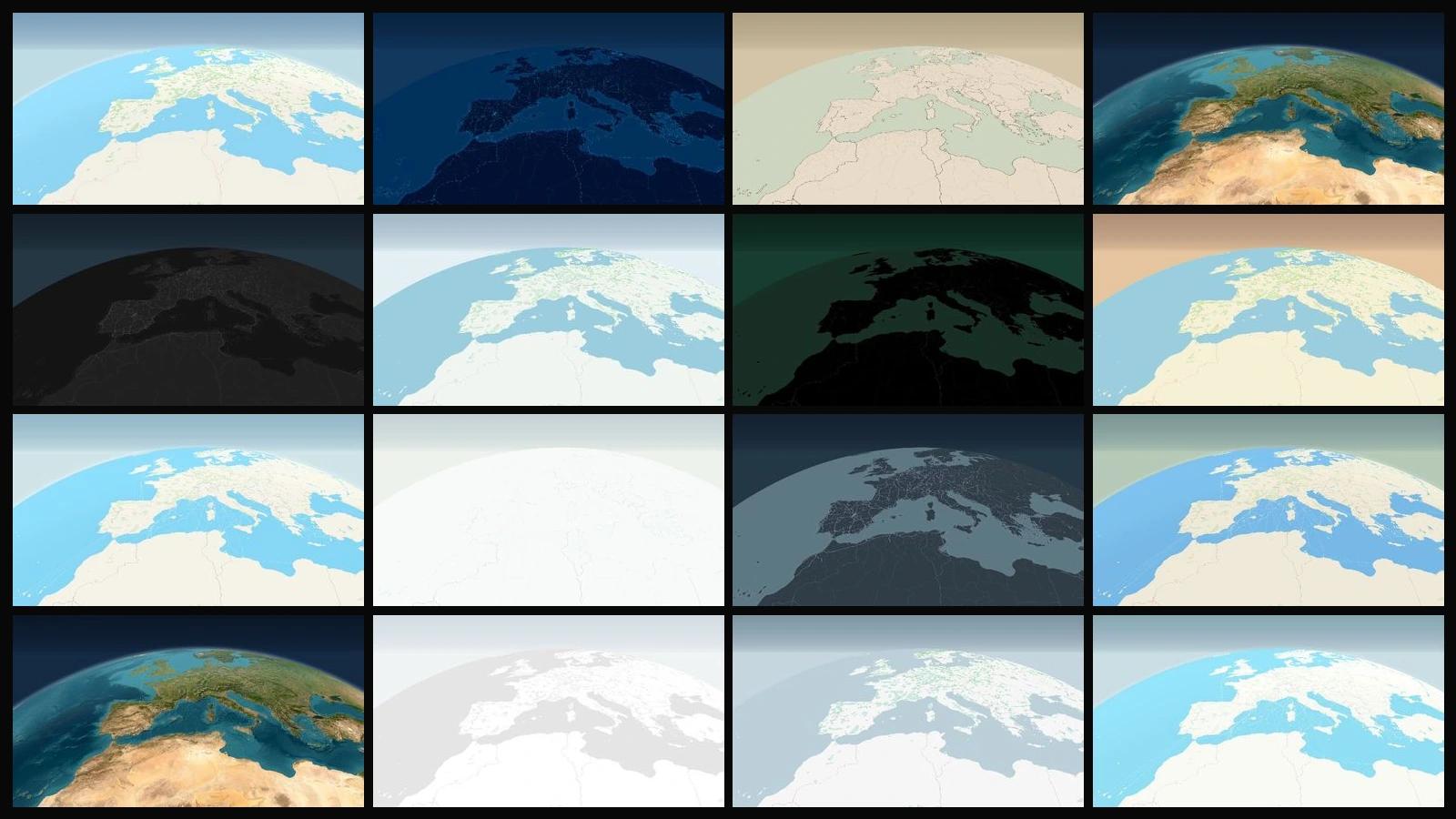
The map is the main character in every animation. This update starts with what you see most: we have revisited all 16 MapsAnimation map styles, from classic cartography to signature designs and satellite views. Each family has colours, labels, roads and a sky that support its character.
The collection gives you more ways to tell a story. Alongside it come eight projections, terrain and weather controls, music and sound effects, camera and timeline improvements, cloud export and a fuller plan comparison. This announcement brings together the additions to Studio and the website.
The headline update: 16 maps with a stronger visual identity
A travel documentary, a data explanation and a city animation call for different visual choices. The revised collection lets you set that direction from the start: clean maps, night scenes, winter landscapes, technical linework, historical cartography or imagery of the actual terrain.
The changes go well beyond a background colour. We revisited the relationship between land and water, vegetation, road hierarchy, boundaries, buildings and the readability of place names. The signature styles recover their distinctive features, while the classics provide a clear foundation for your routes, text, shapes and icons.
Five classics to build your story
Standard is now the starting point for new projects and the Reset option. Cream land, soft vegetation, pale blue water and clear roads leave room for the content you add.
Dark uses neutral greys and almost black water as a contrasting background for bright routes and annotations. Light offers a quieter treatment, with whites, greys and subdued place names that support a simple composition.
Streets brings out the urban structure with cyan water and distinct road hierarchies. Outdoors separates forests, parks, paths and natural areas through olive and beige tones. These five classics provide different starting points with a clear visual purpose.
Signature styles with their character restored
Blueprint pairs navy blue and cyan lines with the character of a technical drawing. Coastlines, paths and place names create a graphic reading of the territory, particularly suited to infrastructure or urban journeys.
American Memory returns to an almost white map, with soft blue coasts, a graticule and restrained labels. Decimal restores black land, jade water and green text, with multiple road hierarchies. Their contrast can give the same camera view a very different mood.
Celestial keeps its historical inspiration: parchment, olive water, ink coastlines and widely spaced names. Its globe has the character of an old cartographic object. Try these four styles with the same camera to see how strongly the map changes the story.
Winter, Snow and Warm: let the landscape set the mood
Winter combines almost white surfaces, ice blue parks and grey blue water. Snow adds a white and mint palette, cool vegetation and blue grey roads. They offer two directions for mountain routes, seasonal travel or a scene with a winter atmosphere.
Warm uses cream and yellow land, warmer vegetation and grey blue water. The difference is visible at a global scale and continues as you move closer. Combine these palettes with weather and time of day controls to develop the atmosphere of your composition.
Improved satellite views bring the real landscape closer
Satellite and Standard Satellite use Esri World Imagery in the platform's current configuration. The change lets you explore cities, coasts and landscapes in much greater detail where the provider has coverage. Standard Satellite combines the imagery with roads, boundaries and labels for orientation.
Both work with Studio's composition tools and projections. Move from a planet view to a specific place and add your own elements. Image dates and resolution vary by location: the available zoom level does not guarantee uniform photographic detail around the world.
Satellite maps require Pro or Enterprise. The selector shows real previews and identifies the plan requirement before you choose them. The five classics remain available in Starter; signature and navigation styles retain their access conditions.
A matching sky for every style and real previews
The redesign extends beyond the surface. All 16 styles have a sky that follows their palette: technical blue for Blueprint, jade tones for Decimal, parchment for Celestial and a space atmosphere with stars for satellite maps. When you reveal the horizon or pull the camera back, the background supports the map.
Time of Day presets let you develop a different lighting treatment and atmosphere. Turning them off restores the selected style's sky. Frame sky and sun also helps open up a horizon view without having to find that camera angle manually.
The style selector now uses previews captured in the actual map engine. Each combines a city and globe view, letting you compare cartography, horizon and sky before applying a style. Lightweight images display the collection without mounting a separate live map for each card.
Eight projections and more control over terrain
There are more ways to present the world. Studio offers Globe, Mercator, Albers, Equal Earth, Equirectangular, Lambert Conformal Conic, Natural Earth and Winkel Tripel. Choose a planet view, a flat global presentation or a regional projection to suit your subject. Albers and Lambert include centre and standard parallel controls.
Routes, text, shapes, icons and measurements continue to use geographic coordinates. Terrain, hillshade and contour controls bring relief to the composition. Buildings can follow the style's original colours or use your own colour and opacity, with an option to restore the original appearance.
We also revisited projection changes and loading during camera movement. Playback keeps the last complete image visible while the next view loads, and rapid seeks respect the latest position you selected. If a resource fails, Studio offers a loading retry.
Six weather layers you can compose
Clouds, precipitation, pressure, wind, temperature and snow have controls for amount, position, rotation, size, opacity and zoom limits. Change their distribution with a seed and keep that exact choice in the project.
The Weather switch controls the whole group: turning it off and on restores your selected layers and settings. The fields adapt to the globe and flat projections, and you can combine them with animated rain and snow particles. These are visual resources for composing scenes, not a weather observation or forecasting service.
Music and sound effects inside Studio
Your personal assets now include a Music and audio library organised into Music and Sound effects. Upload multiple files, listen before using them, drag them to their track or add them at the current playhead position.
Timeline clips support trimming, moving, volume and fades in and out. The mix follows playback and is included in local and cloud exports. Choose music, sound effects, all audio or a silent video when exporting. Uploads use your plan's asset storage allowance.
Smoother editing from the camera to the timeline
We continue to refine playback, timeline scrubbing, transforms and touch controls. Camera presets, keyframes and audio tracks work alongside a map that retains its filters and effects as you change views.
Style changes preserve your composition work, and controls let you return to the map's own settings when needed. Place and route search, selection tools and measurements remain part of the same editing workflow.
Local and cloud video export
The export panel lets you choose local rendering or cloud rendering for video. Local rendering uses your device. Cloud rendering processes the job separately: once it is accepted and queued, it can continue after you close the tab, and you can keep editing while it runs.
On returning to Studio, check job status, preview completed results or download them. Cloud results remain available for seven days. The map, camera, visual layers and audio mix share Studio's composition. Format, resolution, duration and availability depend on your plan and the selected export mode.
Clearer plans and a website that supports the editor
The expanded plan comparison puts Starter, Pro and Enterprise features and limits in one table. Satellite access is visible alongside account usage, exports and storage information. Visit Pricing for details and manage your subscription from your profile.
These additions continue the 2.0 redesign: a homepage with a Studio sample, shared navigation, searchable projects with list and grid views, the gallery, documentation, support, roadmap and a separate News section. The interface keeps its 16 languages, with the new controls integrated into the same workspace.
The best way to see this update is to change the map. Open Studio, keep one camera view and compare Standard, Blueprint, Decimal or Celestial. Then try a sky, a projection and an audio track. The same location can become a very different story.
Product sources
This announcement covers MapsAnimation changes checked against the style selector, Studio controls and project documentation. The MapsAnimation documentation explains the tools and their conditions of use. For background on the mapping technologies, see MapLibre's globe with atmosphere example and Esri's World Imagery integration guide.